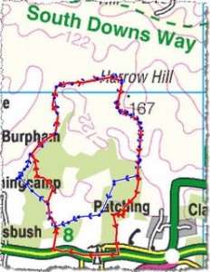
A couple of gifts for Christmas this year were a hand-held GPS device and a digital map of the South Downs. On Thursday this week, wife, oldest son, youngest son and their wives trusted me to take them on a walk on the edge of the Downs, starting 10 minutes from our home. Starting after lunch on a day overcast with winter cloud we left the car park and the GPS guided us along the planned route–until I missed a left turn. This new toy guided us back to the route after a scrabble through the woods. So far, so good. On the return part of our walk we had to pass through another wood.
After a stiff ascent into it we were faced with a four-way junction and less light, even though most trees were bare of leaves. Not quite trusting this new intrument, we decided on a path that proved to be the wrong one. Unlike at the previous correction, we seemed to go deeper and deeper into the wood and get less and less help from the GPS. Our planned route is the blue line and our actual track is the red one. As light faded totally we headed due south towards the major road we could hear. Then youngest son and I hoofed it along this road back to the car park, leaving the rest of the party to find their way to the nearest hostelry, where we joined them later. Resolved: a) to take a traditional compass on future walks; b) to take a torch; c) to learn how to use aforementioned GPS; d) to avoid woodland paths after dark.
30 December, 2006


